You should confirm boundaries at the start of the purchasing process. During the conveyancing process, your solicitor should highlight any existing boundary issues from their review of the documents, or as set out by the seller of the property. As an existing owner, you may also wish to confirm your property’s boundaries, for example prior to any changes you wish to make to the house or garden.

Consumer Guide
Topographic surveys and boundary disputes: how to establish your property’s boundaries
-
 Email
Email
-
 Facebook
-
 Linkedin
-
 Twitter
-
 Whatsapp
This page explains what a boundary is and when a topographic survey – carried out by an RICS professional – may be useful in resolving disputes about them.
This information is for consumers based in the UK.
How to avoid boundary disputes
‘Good boundaries make good neighbours’ is a well-worn phrase for a reason. When the boundaries between properties are not clear, this can lead to disputes, which can cause stress and are costly and time-consuming to resolve. To avoid conflict over boundaries, it helps to understand the position and condition of the boundaries of your property, and establish a relationship with your adjoining neighbours.
How are property boundaries governed?
In England and Wales, a general boundary system is in place. HM Land Registry records the ‘general boundary’ on the ‘title plan’ using Ordnance Survey (OS) mapping to ‘indicate’ the extent of a registered title, creating a title plan for each property. Rules about land and boundaries are different in Scotland and Northern Ireland.
What is a title plan?
A title plan shows the land included in a property registered with HM Land Registry. The red line on the title plan indicates the extent of the registered land and the ‘general’ position of the boundary, based on existing topographical features shown on OS mapping.
HM Land Registry use the available OS mapping at when creating the title plan, so there may be variations between adjacent titles. Bear in mind that title plans do not show exact boundaries (unless the boundary has been determined and recorded as such) and do not define the ‘legal’ boundary. However, the level of detail is usually sufficient to establish a ‘general’ agreed boundary between residential properties and can be relied on by most . Scaling up title plans to get the required level of detail is not advisable. In these cases, a topographic survey will be able to provide you with the level of detail you require.
What is the ‘paper title’ and the ‘legal boundary’?
Where a boundary is created by a conveyance of land, the ‘paper title’ boundary is also the legal boundary. When trying to establish your boundaries, it can be useful to identify the originating conveyance that created the legal boundary in question. However, this may be difficult to obtain if the division of land goes back many decades – or even centuries.
While the paper title boundary remains unchanged over time, the legal boundary can change after the date of the first conveyance as the land is used over time. For example, a formal or informal boundary agreement between neighbours can change the legal boundary.
What is the ‘physical’ boundary and an ‘established’ boundary?
While a paper title or legal boundary is an invisible or a theoretical line, the ‘physical’ boundary describes a physical feature, such as a fence, a wall or a hedge, that has demarcated the boundary for a substantial number of years. Whether this established physical boundary has become the legal boundary, as well as the relationship between the physical feature and the legal boundary, is a matter of law.
How do I know what the boundaries of my property are?
- Obtain the conveyances/transfers of the property from your lawyer or conveyancer.
- Obtain the HM Land Registry title plan from the HM Land Registry website.
- Compare the conveyances/transfers or HM Land Registry title plans to your existing boundaries. If you are in the process of buying a property, you should compare the title plan to the property documentation before exchanging contracts. Ask the seller to clarify any differences. The seller may need to seek the advice of a chartered surveyor specialising in boundaries to do this.
- Look at the physical features. Most properties have physical features that help define the boundaries. Look for fences and walls, sides of buildings, hedges, roads, ditches, edging stones, rivers and streams. Bear in mind that small differences, such as a jut in a fence, may not be illustrated on either the title plan or any conveyance or transfer plan.
- Talk to the neighbours! They may have working assumptions about where the boundaries lie and who maintains what (such as who is responsible for repairs to fences). Establish a relationship so you can resolve any issues without conflict.
What should I do in a boundary dispute?
In the event of a dispute over where the boundary lies, it is important that you and your neighbours obtain all the available information about your boundary listed previously, and ideally share that information with each other and try to come to an agreement.
If you are unable to come to an agreement, a topographic survey undertaken by a chartered land surveyor may help. You can find surveyors who specialise in boundary disputes through the RICS Find a Surveyor website.
What is a topographic survey?
A topographic survey, sometimes referred to as a land or measured survey, is the process required to record the location of both the natural and man-made features in an area, and then produce an accurate and detailed plan identifying them. The collected data can be presented in many formats, from a simple paper plan to a full 3D digital model, depending on your requirements. Today, the most common presentation is as a PDF. Topographic surveys are most commonly used for commercial property projects but can also be used for domestic properties and to help solve disputes.
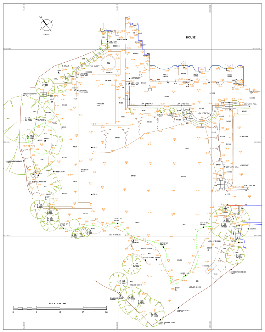
Copyright GAJ Surveys Ltd
Should I get a topographic survey to help establish my boundary?
A topographic survey is a detailed measurement of the physical landscape (land and buildings), which can help provide a more accurate determination of boundaries. However, it is usually only needed:
- in the event of a dispute between neighbours where existing information about the boundary from physical features, conveyances or HM the HM Land Registry title plan is unclear or disputed
- If you are planning construction works which will remove the physical boundary features, to enable a reconstruction of such features after the construction work is completed.
Different types of topographic surveys
Different types of topographic surveys are useful depending on the type of project you require the survey for. Talk to your surveyor about your project and what you would like the topographic survey to help you achieve. The purpose of a topographic survey will determine the appropriate survey and its cost. Find a land surveyor with our Find a Surveyor service.
Bear in mind that a topographic survey prepared for one purpose may not necessarily be suitable for another purpose. For example, surveying the outline of buildings to be demolished is not carried out in the same detail as a measured building footprint.
A topographic survey can be used for a large number of purposes, but common domestic purposes include:
- redevelopments or additions to existing buildings
- buying and selling land
- location of boundaries and neighbouring property details for rights of light or party wall issues
- location of specific items of detail for engineering/maintenance purposes
- defining the layout of surface infrastructure and services, and
- locating and identifying trees and tree canopies, vegetation classification and land use studies.
How is a topographic survey carried out?
Land surveyors have access to a wide variety of survey equipment, including satellite technology, drones, theodolites and laser scanners. The land surveyor will decide which survey equipment to use based on the agreed topographic survey specification.
Topographic surveys can be used in conjunction with appropriate Ordnance Survey mapping. Your surveyor will ensure that the difference between the actual surveyed features and Ordnance Survey mapping is clearly identifiable.
What are the benefits of a topographic survey?
A topographic survey will provide accurate land and building measurements, and a record of the physical layout of an existing site. This will then be used by the surveyor to demonstrate their professional opinion on the land and any boundary. This can assist landowners to make agreements about boundaries and/or the best use of the land.
Architects, contractors, planners and engineers regularly use topographic surveys to provide informed advice and guidance to their clients. An accurate topographic survey can help to prevent unforeseen issues or boundary disputes.
How much does a topographic survey cost?
The price of a topographic survey will depend on what is being surveyed and the level of detail needed. The size of the area of land, the equipment the surveyor needs to use and whether the surveyor needs to travel to the site will determine the time it takes to survey, process the data and then draw the plan.
It is important to think about what you want the survey to record and discuss with your surveyor what you are intending to use the topographic survey for. They will be able to advise you on what type of topographic survey is right for you, and provide different options and quotes.
Use our Find a Surveyor service to find a surveyor to undertake your topographic survey. RICS-regulated firms can provide you with peace of mind, as they are working to the highest professional standards and have professional indemnity insurance.
How to maintain a boundary
As many properties have physical features that define the boundary, it is important to keep these in good condition. Letting fences fall or hedges grow excessively may lead to your boundary being harder to recognise. Ensuring these features remain stable and clear will help avoid disputes with your neighbours about where the boundary is.
If some or all of your boundaries are not clearly defined, you and your neighbour need to understand and agree where the boundary is. You may wish to discuss with them whether establishing an appropriate boundary feature, such as a fence, wall or hedge, might be useful in marking the area. Never establish these without your neighbour’s knowledge or while they are away. Always discuss any planned work around the boundary with your neighbours before you begin.
Summary
You can avoid boundary disputes with your adjoining neighbours by sourcing information about the position of the boundaries of your property, maintaining the physical condition of those boundaries and establishing a relationship with your neighbours.
Topographic surveys are a way to record more detailed information about boundaries and are most often used during dispute processes, or in large commercial or development projects. Use a chartered surveyor to undertake your topographic survey, to ensure you have accurate and impartial information to help your project.
Boundaries and topographic surveys FAQs
Related articles
You may also be interested in reading:
- Property Boundaries (gov.uk)
- Land and Property information in Scotland (ros.gov.uk)
- Land Registry of Northern Ireland (nidirect.gov.uk)
- The Survey Association’s Client Guide for Topographical Suveys (www.tsa-uk.org)
- The difference between OS maps and HM Land Registry property boundaries (ordnancesurvey.co.uk)
- A day in the life of a geospatial surveyor (rics.org), where the surveyor describes how she undertakes topographic surveys and turns them into reports to help clients
- HM Land Registry blog and video (gov.uk), Drawing the line on boundaries